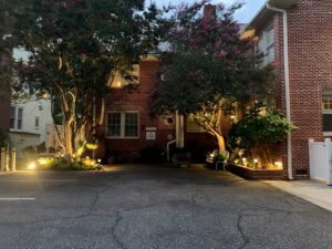
Parking is located behind the house, and there is one parking space per room. You can enter the alley that runs behind the house from either side of the block, either from Williams Street, or Toy Street. Pettigru Place is the only red brick, multi-story house in the alley. If it is dark when you arrive, look for the twinkle lights in the trees in the parking lot. Additional street parking is available, but limited.
From Columbia: Take I-26 West from Columbia to I-385 North toward Greenville. As you approach downtown Greenville, I-385 will become East North St, and within 2 blocks you will come to a stoplight (at the Bon Secours Arena (formerly Bi-Lo Center). Turn left onto Williams St. Go one block to Pettigru St. Turn left. We are the second house on the right, at 302 Pettigru St. Parking in the rear can be reached from either end of the block.
From Charlotte: Taking I-85 South from Charlotte, follow to I-385 North/Exit 51C toward Greenville. As you approach downtown Greenville, I-385 will become East North St, and within 2 blocks you will come to a stoplight (at the Bon Secours Arena (formerly Bi-Lo Center). Turn left onto Williams St. Go one block to Pettigru St. Turn left. We are the second house on the right, at 302 Pettigru St. Parking in the rear can be reached from either end of the block.
From Atlanta: Taking I-85 North from Atlanta, follow I-85 to Exit 42 for I-185/US 29N (Greenville). I-185 will become Mills Ave., then it will become Church St. After crossing the bridge in downtown Greenville, turn right at E. Washington St. Go one block and turn left onto Pettigru St. Go two blocks to 302 Pettigru St. We are on the right.
From Asheville: Taking US 25 South from Asheville, follow to US 276 S. US 276 will become Rutherford Rd. Take this until it dead-ends into Buncombe St. Turn left on Buncombe. It becomes W. North, then E. North. Turn right onto Williams St (at the Bon Secours Arena (formerly Bi-Lo Center). Go one block to Pettigru St. Turn left. We are the second house on the right, 302 Pettigru St.
Approximate Driving Times
- Asheville, NC – 1 hour
- Atlanta, GA – 2.0 hours
- Charleston, SC – 3.5 hours
- Charlotte, NC – 1.5 hours
- Columbia, SC – 1.5 hours
Directions to Main Street (0.5mi): From the front of the house (Pettigru St.) turn left on Pettigru st., crossing over Williams St. At the end of Pettigru St. turn right onto East Washington St. Main Street will be 0.4 miles ahead.
Directions to Bon Secours Wellness Arena (0.2 mi): From the front of house (Pettigru St.) turn right on Williams St., staying on the left side of Williams. Cross over East North Street. The Main entrance will be in front of you.
Directions to Bob Jones University: From the front of the house (Pettigru St.) or from the parking lot, turn right on Williams St. Cross over E. North St./I-385 and continue to next traffic light and take a right on Church St. Turn right on Wade Hampton Blvd. and continue for 1.5 miles. The campus entrance will be on your right.
Directions to Furman University: From the front of the house (Pettigru St.) or from the parking lot, turn right on Williams St. Turn left at the traffic light onto E. North St. Continue for 1 mile and turn right on US 276 N/Rutherford St. Follow for 7 miles and the campus entrance will be an exit ramp on your right. (The campus itself is on the left side of the road.


